Improving surface mapping using GNSS reflectometry
This work investigates new approaches for improving surface mapping using GNSS reflectometry within distributed satellite configurations. Current GNSS-R observations can face limitations in spatial coverage and mapping capability due to the geometry between satellites, receivers, and the reflecting surface. Inspired by earlier work on radar imaging using signals of opportunity, my research investigates whether a coordinated swarm of nanosatellites carrying GNSS-R receivers can act collectively like a synthetic aperture radar (SAR) to reconstruct detailed 2D maps of the earth’s surface. We also explore the benefit of using multiple frequency bands (GPS L1, L2 and L5) simultaneously to suppress the Doppler noise.
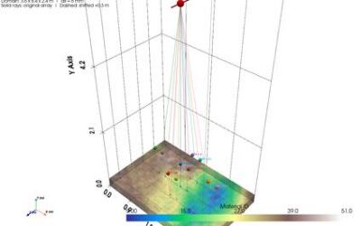
We conduct simulation studies using realistic satellite orbit scenarios. In our setup, six nanosatellites fly in a closely spaced formation in LEO orbit and collectively process the reflected GNSS signals. By coherently combining the data accumulated over time and across satellites, we can retrieve an image of the observed area. Both simple point targets and more complex 2D surface objects are simulated and tested, allowing us to assess resolution, image sharpness, and the ability to distinguish fine details.
Our simulations show that the swarm concept is feasible for producing meaningful surface images in ideal case with a spatial resolution of 200 meters. When signals from multiple satellites and frequencies are combined, the resulting maps are able to reproduce the overall shape and key features of a test surface with improved clarity compared to single-satellite observations. Longer observation times (e.g. 1000 msec would be enough) and larger satellite swarms lead to sharper, cleaner images. We also found that targets located away from the direct specular reflection point (e.g. 20 km away) tend to benefit more from this approach.
Future work will focus on more realistic signal and surface models, account for noise and signal attenuation under practical conditions. The methodology will also be evaluated using data from existing satellite missions to further validate the approach. This will help establish the technique as a reliable tool for wide-area Earth observation.
Some materials I find meaningful:
[1] Simon H. Yueh et al., “ASatellite Synthetic Aperture Radar Concept Using P-Band Signals of Opportunity”, DOI: 10.1109/JSTARS.2021.305924
[2] Li et al., “Exploration of Multi-Mission Spaceborne GNSS-R Raw IF Data Sets: Processing, Data Products and Potential Applications”, DOI: 10.3390/rs14061344
[3] Fan et al., “Spatiotemporal Evaluation of GNSS-R Based on Future Fully Operational Global Multi-GNSS and Eight-LEO Constellations”, DOI: 10.3390/rs10010067
[4] Jin et al., “Remote sensing and its applications using GNSS reflected signals: advances and prospects”, DOI: 10.1186/s43020-024-00139-4
[5] Pierdicca et al,. “Retrieval of Biogeophysical Parameters From Bistatic Observations of Land at L-Band: A Theoretical Study”, DOI: 10.1109/TGRS.2021.3076051