GNSS-R Interferometry for Subsurface Soil Characterisation
The goal of my research is to apply interferometric algorithms using passive GNSS-R (Global Navigation Satellite System Reflectometry) data to study the response of the ground — in particular its reflection responses (Green’s functions) and the physical parameters associated with it, such as electrical conductivity and permittivity.
By exploiting signals simultaneously acquired by multiple receivers and from multiple GNSS satellite sources, I am working towards applying interferometric techniques to improve the retrieval of ground reflection responses, with the aim of increasing imaging resolution. My research currently focuses on the near-surface layers of heterogeneous soils with compositions typical of agricultural and crop fields. Future developments will address the introduction of more complex models incorporating surface roughness and subsurface elements.
Electromagnetic Modelling
A key component of my work is the development and validation of physics-based electromagnetic (EM) models to simulate the behaviour of reflection responses in a GNSS-R configuration. The objective of these models is to act as surrogate models — that is, to reproduce the physical behaviour of complex reflection and scattering phenomena through fast, computationally efficient forward models, so that they can be used directly within interferometric inversion algorithms.
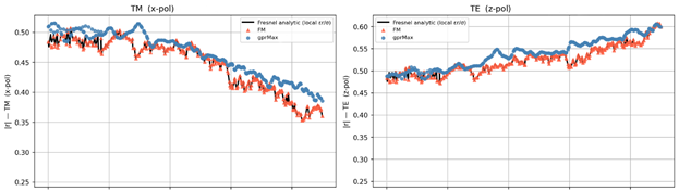
In particular, I am currently developing an EM forward model based on the Stationary Phase Approximation (SPA). In this framework, the reflected signal is assumed to originate primarily from a single dominant point on the surface — the specular reflection point — where the geometry of the incoming and outgoing signal directions satisfies Snell’s law. At this point, the reflectivity of the ground is described by the Fresnel coefficients, which depend on the soil’s dielectric properties and the angle of incidence. This approach is computationally very efficient and provides a physically interpretable description of the reflected waveform, making it well-suited for integration into real-time retrieval algorithms.
Validation with full-wave electromagnetic solvers
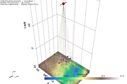
To validate these surrogate models, I use reference simulators based on exact numerical solutions of Maxwell’s equations — primarily solvers based on FDTD (Finite-Difference Time-Domain) and FDFD (Finite-Difference Frequency-Domain) methods. These tools, such as gprMax, numerically solve the full electromagnetic problem on a fine 3D grid, capturing all wave phenomena including reflections, diffractions, and scattering, without any of the simplifying assumptions made by the surrogate models. Simulations are run at GPS L1 frequency (1.575 GHz) with multiple receiver positions covering a range of incidence angles, allowing a systematic comparison between the full-wave reference and the SPA surrogate.
Ongoing Work
During a research visit at Polychord Ltd (London, UK), I had the opportunity to engage with statistical algorithms based on Bayesian inference. I am now integrating these methods into my research, with the goal of laying the foundations for the inversion algorithms that will ultimately retrieve soil parameters from GNSS-R observations.
A research collaboration with UCLouvain (Louvain-la-Neuve, Belgium) is planned, where I will have access to realistic measured data acquired using arrays of GNSS receivers mounted on drones, enabling controlled multi-receiver, multi-angle acquisitions over real agricultural fields. This will provide a crucial validation step, bridging the gap between the synthetic simulation environment and real-world deployment of the interferometric retrieval algorithms.