Drone-borne GPR and satellite remote sensing
1. Drone-Borne Ground Penetrating Radar
While satellites provide a broad overview of the Earth’s surface, they often lack the fine detail required for managing specific fields or small-scale hydrological studies. To bridge this gap, the GPRLouvain research group has utilized the Hexadrone Tundra-1 unmanned aerial vehicle (UAV) as a specialized experimental platform.
By equipping the drone with an L-band Ground Penetrating Radar (GPR), we can capture the dielectric properties of the soil—essentially measuring how much water is held in the upper layers—without ever touching the ground.
Why this matters for the GLITTER project:
- Direct Calibration: We use these drone flights to provide high-resolution “ground truth” data. This helps us confirm that our larger satellite observations are accurate.
- Non-Invasive Mapping: We can map soil moisture across difficult terrain or active farmland quickly, providing a level of detail that manual sensors simply cannot match.
- L-Band Consistency: Because our drone radar uses the same frequency band as L-band satellites, the data is perfectly suited for validating global observations.
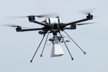
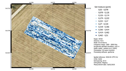
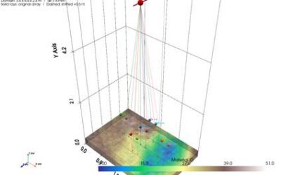
Figure 1 The L-band GPR mounted on a drone and Soil moisture map generated from drone GPR measurements
2. Satellite Remote Sensing
Accurate, field-scale soil moisture data is vital for farming and water management, but no single satellite can do the job alone. L-band radiometers (like SMAP) are highly reliable but provide very large, fuzzy pixels. On the other hand, C-band radar (like Sentinel-1) offers sharp detail but can be easily distracted by plant growth or the roughness of the soil surface.
We have developed a framework that combines the best of both worlds. By fusing SMAP’s moisture data with Sentinel-1’s detailed backscatter, our model creates a much clearer picture of the landscape. To make the model smarter, we also include:
- The Soil Moisture Index (SMI): Based on historical highs and lows of radar signals.
- Environmental Context: Data on vegetation (NDVI), rainfall patterns, and local topography.
We tested several tree-based machine learning models using a strict timeline: training on data from 2020–2024 and testing on 2025. The XGBoost algorithm emerged as the leader, providing the most accurate moisture maps when compared against actual ground sensors.
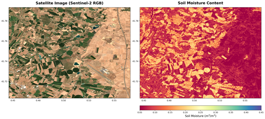
One of the most exciting results is the model’s ability to identify center-pivot irrigation systems in the Barcelona region. These appear as distinct moisture circles, proving that our model is now sharp enough to detect human-scale agricultural activities from space.